Jacoby Hollow is a bit of a gem for naturalists.
Except for fields at the mouth of the valley, the entire watershed is on the
Loyalsock State Forest. The only view of the valley is from a road through
those fields.

There’s a decent trail into the hollow that
generally parallels the stream; in the beginning a small wetland is crossed on
a boardwalk, but from then on it’s a woodland trail –

The valley generally trends north-northeast as a
hiker walks upstream, so the hillside to the right faces northwest and is
generally cool and moist while the hillside to the left faces southeast and
tends to be warmer and drier. The valley's vegetation reflects those different aspects and the environments they create.
The trail passes some large white pine and through stands of hemlock –
The trail passes some large white pine and through stands of hemlock –


My first visit to the hollow was in 1974 with a hiking
buddy whose mother and sister had been killed in the gas chambers during World
War II; in later years our oldest granddaughter and a group of hiking friends
also visited the valley and its falls in winter; I’ve taken hikes into
Jacoby Hollow in other seasons as well –

The real highlight of Jacoby Hollow is Jacoby Falls,
at 29 feet the highest waterfall in the county –

One distraction from the beauty of Jacoby Hollow has
always been the pipeline that follows the stream, crosses it multiple times and is
even beneath the streambed in places –

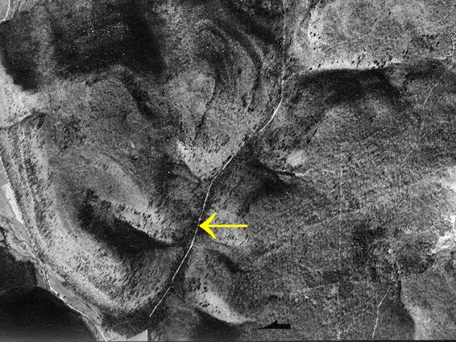
The pipeline is old, appearing in an aerial photo
taken in 1938 –
 Then on the night of October 21, 2016 between six and
ten inches of rain fell in less than six hours. The stream roared down the
valley, as did all the nearby streams, and into a larger stream which the
pipeline also followed and crossed several times. The “high water event” tore
out a road bridge, uncovered the buried pipe in many locations, and ruptured
the pipeline that, according to PennLive, spilled 52-55,000 gallons of gasoline
into the water.
Then on the night of October 21, 2016 between six and
ten inches of rain fell in less than six hours. The stream roared down the
valley, as did all the nearby streams, and into a larger stream which the
pipeline also followed and crossed several times. The “high water event” tore
out a road bridge, uncovered the buried pipe in many locations, and ruptured
the pipeline that, according to PennLive, spilled 52-55,000 gallons of gasoline
into the water.

I’d not been to Jacoby Hollow since that event but
recently decided to go back. The route of the old pipeline is now the
equivalent of a road –

Apparently repairs to the pipeline are still underway
since sections of new pipe are laid out awaiting installation –

Shortly before reaching the waterfall the pipeline
leaves the stream and from there the stream is still beautiful –

As are the falls; because
the watershed above the falls is only about 500 acres, the waterfall can be a
mere trickle –

But then there are the heavily disturbed stream and the pipeline right-of-way –

The question of why the damaged pipeline
wasn’t moved out of the valley arises; surely a major storm event will occur again
– especially as the climate changes. The scars may not heal within my lifetime
and I may not go back.
I agree with you, Woody. Why would a damaged pipeline NOT be moved out of such a beautiful valley? So disappointing! Your photos are beautiful, but I can certainly understand why you would not want to return to the scene of destruction.
ReplyDeleteKay
An Unfittie's Guide to Adventurous Travel
Sad story and good question. A scenario repeated throughout our wild lands.
ReplyDeleteIt's sad to have our special wild places scarred this way. I guess it would have cost more to move it than to repair it, even though the damage may come again. I have a favourite trail that has a row of lovely hydro towers (the big ones) right through the middle of it. It does provide an open view for quite a ways ... got to see the bright side of some things.
ReplyDeleteWendy
thank you for post reply
ReplyDeleteทางเข้า D2BET